
Forests can be visually packed and full, yet functionally misunderstood. We see the luscious green and chirping sounds and appreciate it without question. But what we see alive and good, is how good in quantifiable terms?
There are areas where there are no ecological services managed for, and where there is no biodiversity to speak of, the economic value of such services is not recognized to a sufficient extent also their function in the ecological resilience of landscapes is not yet transferred into planning decisions. So, even though the forest may look like it is full of trees, it can still feel very empty - not of trees - but of attention, of value, and of responsible stewardship of nature’s vast potential for increase of all sorts of abundances.
Benefits that are frequently undervalued include those provided by forests (see Figure 1). Such benefits include regulating services as indicated by decadal information of FAO and UNEP (2020) having vast biodiversity around 60,000 tree species, harboring 80% of amphibians, 75% of birds, and 68% of mammals in global scale. A forest moderates local climate and offers a host of other services that support human health and well-being. Undervaluing these ecological services is largely due to the fact that their indirect effects, or impacts, typically occur in the short-term as priority is more on earning and the benefits of the people per se. Exact outputs are often difficult to put a price on (Millennium Ecosystem Assessment, 2005) and will often be a projection. It is often readily apparent what positive impacts are occurring when a field is cleared of trees and put into production to harvest a particular crop and to subsequently sell that crop on market.
Trees are often perceived as obstacles to increased agricultural production or as single commodities such as timber. However, trees can be managed as living infrastructure to enhance carbon sequestration. For example, Pan et al. (2011) estimated 860 to 861 billion metric tons of carbon stored from 1990 to 2007 globally. Not just as carbon sinks, but forests also promote biodiversity, improve soil quality, or regulate water and air. Additionally, trees are good companions when joined into various agricultural production systems such as annual crop systems, livestock production systems, or perennial crop systems (Jose, 2009). Commonly known as agroforestry, trees can humanize forest functions and improve forest ecosystem services. However, forest functions and forests themselves need time to recover. Nature does not proceed as quickly as decision makers and project managers do. Soil takes years to be completely restored to its functions. Tree roots need time to bind up slopes. The canopy of a young forest takes years to cool down the land. Biodiversity is lost in a very short time, but it also recovers in a short time, if the right conditions are given to it. In some cases, it is sufficient to protect natural regeneration. In other cases, assisted natural regeneration, enrichment planting or agroforestry systems are used to support the ecological functions of forests and to generate new income opportunities for farmers and rural communities.
Therefore, information collected from above ground can now be used to monitor changes in forest cover, biomass and carbon stocks over space and time (Goetz & Dubayah, 2011; Maxwell et al., 2018). Using spatial data from a variety of sources, the most complex land-cover patterns can be automatically classified using machine-learning (ML) and artificial intelligence (AI) techniques. This spatial information can be used to identify degraded forest areas and assess the condition of existing forests. It can also be used to estimate a variety of forest ecosystem services, and project the future development of both forest landscapes as well as agroforestry systems. The application of Geographic Information System (GIS) mapping, Python-based algorithms, remote sensing, machine learning and Artificial Intelligence (AI) facilitates quantifying and projecting the ecosystem services of forest and agroforest landscapes. Thus, making the often-invisible services provided by forests visible and quantifiable. With the help of spatial models, it will be possible to outline which areas of a landscape should be protected, which areas can be restored, and which areas can support agroforest systems. In turn, it can generate ecological and economic benefits.
As such, the Land Equivalent Ratio (LER) is one of practical options as it has been widely used for intercropping and agroforestry systems, by comparing them with single crop monocultures, using crop yield as a basis for comparison (Mead & Willey, 1980). In forest-agroforestry planning, the concept of LER can be expanded to include other important services that trees and agroforestry systems can provide, for forests as well as for agroforestry systems. This could include, for example, carbon storage, conservation of soil, water, and biodiversity, as well as support for rural livelihoods. By using all these services as a basis for comparison, the maximum LER can be quantified for different forest and agroforestry systems.
Thus, combination of the LER and technological approaches could quantifying ecological services that forests and agroforestry systems can provide, and a more complete view of the value of trees can be obtained. All trees are used for timber or as part of an agroforestry system for crops, for example, would have a limited value. On the other hand, riparian forests can protect water resources from pollution and water loss, and in shaded agroforestry systems, climate change can be adapted. Spatial maps can be made that provide insight into the many services that nature can provide and the value that these services can have for mankind.
The use of technological approaches to analyze the forest landscapes where we live requires a healthy dose of humility and respect for the ecological processes that occur there as well as for the practices and cultures of human communities. Approaches that use AI to classify landscapes to quantify their services must be grounded in an adequate knowledge of the ecological processes that are taking place and must be validated through field work. The maps that show the forest cover and the services that forests provide to humans, and the environment can be very useful to highlight what forests are already doing for us and how agroforestry can be designed and managed to work with the forest to enhance its ecological services and to provide economic benefits for local people.
When a dense forest appears to be empty, the problem of valuing the forests already on the land is one of human perception rather than the literal trees themselves. In some situations where agroforestry can work with forest to increase productivity, quantifying the services that are provided by forest and agroforestry landscapes across spaces using the LER and technological approaches could help to reveal their true value and make visible their hidden ecological functions. Trees are not mere objects standing in a landscape but rather are living infrastructures that have the potential to support both climate change resilience, food security and bringing new economic opportunities for rural people.
Measuring the benefits of forests and their functions, wise management of landscapes, and effective agroforestry systems that do not interrupt the natural processes of forests but rather support and enhance them to generate higher levels of production and of economic, ecological and social utility for rural human populations, is a double challenge, it is a scientific and moral challenge. Protecting the forest is not just to give it a name on a map, it is to give value to its functions and to respect them where human intervention in natural processes can be of assistance to nature, work with nature to increase its ecological wealth and diversity, and to generate income for rural human populations.
References
Food and Agriculture Organization of the United Nations. (2020, May 22). UN report: As the world's forests continue to shrink, urgent action is needed to safeguard their biodiversity. FAO. FAO Newsroom
Goetz, S., & Dubayah, R. (2011). Advances in remote sensing technology and implications for measuring and monitoring forest carbon stocks and change. Carbon Management, 2(3), 231–244.
Jose, S. (2009). Agroforestry for ecosystem services and environmental benefits: An overview. Agroforestry Systems, 76, 1–10.
Maxwell, A. E., Warner, T. A., & Fang, F. (2018). Implementation of machine-learning classification in remote sensing: An applied review. International Journal of Remote Sensing, 39(9), 2784–2817.
Mead, R., & Willey, R. W. (1980). The concept of a “land equivalent ratio” and advantages in yields from intercropping. Experimental Agriculture, 16(3), 217–228.
Millennium Ecosystem Assessment. (2005). Ecosystems and Human Well-being: Synthesis. Island Press.
Pan, Y., Birdsey, R. A., Fang, J., Houghton, R., Kauppi, P. E., Kurz, W. A., Phillips, O. L., Shvidenko, A., Lewis, S. L., Canadell, J. G., Ciais, P., Jackson, R. B., Pacala, S. W., McGuire, A. D., Piao, S., Rautiainen, A., Sitch, S., & Hayes, D. (2011). A large and persistent carbon sink in the world’s forests. Science, 333(6045), 988–993.
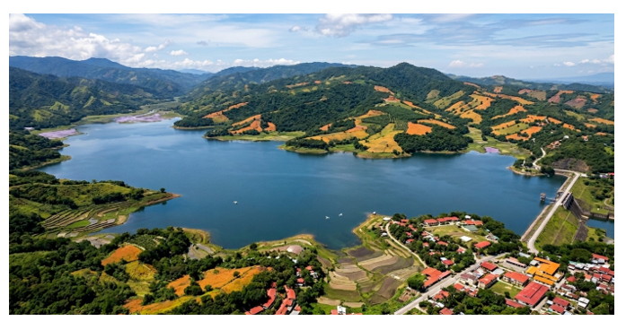
Figure 1. The Pantabangan-Carranglan Watershed demonstrates how forests, agriculture, lakes, and urban areas generate environmental, economic, and social benefits.
