
Emerging evidence from climate research consistently emphasises that global warming and climate change are driving significant shifts in the severity and magnitude of hydrological extremes (HEs), including floods, heavy rainfall, and prolonged drought. Being a tropical island, Sri Lanka faces various effects of climate change, including changes in precipitation patterns, sea-level rise, and an increase in the frequency and severity of extreme events in recent years (Samaraweera et al., 2024). Among these, extreme precipitation, flooding, and drought events are anticipated to intensify and become more frequent under a warming climate (Mishra et al., 2024). These HEs have gained significant attention in recent decades due to their profound impact on watershed hydrology and associated environmental problems. Riverbank erosion is such a significant environmental issue, severely exacerbated by HEs in Sri Lanka in recent decades.
Riverbank erosion is a geomorphological process on Earth's surface in which riverbanks are gradually degraded by hydraulic action and other environmental factors (Muhammad et al., 2024). Even though it is a natural geomorphological process, the increasing severity of HEs under climate change significantly alters the rate and pattern of typical erosion in recent years across many rivers in the country. The Mundeni River, located in the eastern part of Sri Lanka, is highly vulnerable to both wet and dry HEs, which significantly affect watershed hydrology and processes, resulting in substantial changes to the River's physical and social landscapes through bank erosion. As a dry-zone river basin, the rainfall pattern in the Mundeni River Basin is highly seasonal, with a marked concentration of rainfall from November to February, followed by relatively dry conditions from March to August. Due to the climatological and geographical setting of the Mundeni river basin, the problem is much more severe during December and January, as the Northeast monsoon season brings higher rainfall to the basin.
Therefore, riverbanks experience increased erosion and high sediment loads during monsoon floods, which typically occur during these months. Because river flow significantly increases bank instability by adding moisture that weakens the ground base, making river banks more prone to erosion (Mentes, 2019). Apart from these seasonal flow variations and related processes, the area's high vulnerability to cyclones and storms, influenced by the Bay of Bengal, often leads to intense, short–duration rainfall, thereby accelerating riverbank erosion. The recent cyclone Ditwah in November 2026 clearly demonstrated how high-flow conditions can impact river banks, as evidenced by severe erosion at several locations along the river (Figure 1). Within the Mundeni River basin, the Rugam rainfall station recorded the highest 24-hour rainfall total of 300.1mm on 26th November 2026, highlighting the severity of hydrological extreme (HEs) events in the region (Department of Irrigation, 2025). Similarly, during the severe flood event in January 2011, the same station recorded higher rainfall over three consecutive days, with amounts of 130 mm, 120 mm, and 220 mm on the 11th, 12th, and 13th of January, respectively (Department of Irrigation, 2025). This historic flood event caused extensive damage to the banks of the Mundeni River.
As heavy rains saturate soils along riverbanks, increased runoff, sediment transport, and scouring led to bank erosion and small-scale slope failures. Moreover, prolonged drought conditions dry out soil and weaken riverbank vegetation and root stability, making riverbanks more vulnerable to erosion when hydrological flow conditions return. Since higher rainfall events in the basin are followed by long dry periods, soil dryness and weakened slope stability exacerbate bank erosion. During heavy rainfall events and flooding, discharge increases rapidly, leading to high flows and significant riverbank erosion, both of which are strongly influenced by the basin’s landscape characteristics. The river overflows its banks, causing nearby soil to be eroded during heavy rainfall events (Ross et al., 2019). The landscape facilitates overflow because low-elevation flat landscapes dominate the Mundeni river basin, while only the upper and some middle parts are characterised by hilly areas. These higher flows not only erode banks but also widen river channels and increase sediment transport and deposition at various locations along the river. Moreover, the undercutting and saturation of materials weaken soil strength, sometimes leading to slope failures. These hydraulic and hydrological processes, together with anthropogenic activities along the riverbanks, significantly alter river morphology (Leng et al., 2022). Consequently, the regions exhibit several forms of erosion, including hydraulic erosion, undercutting, bank collapse, sheet erosion, rill erosion, and scour erosion.
Along with natural factors such as climate, soil, and morphological characteristics, human activities such as river channel modifications, sand mining, deforestation, and the removal of riverbank vegetation further shape the banks of the Mundeni River. Although human influence is comparatively low along the river, these factors increase the bank's vulnerability to erosion. Accordingly, both gradual and rapid riverbank erosion lead to many environmental and socio-economic problems, including the loss of agricultural land, increased sedimentation, the destruction of infrastructure, and the degradation of ecological services. This process also influences downstream flooding because more sediment is deposited along the riverbed, reducing the river's depth and causing it to exceed capacity, flooding nearby areas. Figure 2 illustrates changes in the riverbank across different years (2009, 2017, and 2025) and clearly indicates gradual land loss due to erosion. Leng et al. (2023) emphasise that riverbank erosion and failure have many adverse effects on local communities and nearby social activities.
Since the region exhibits several forms of erosion, various bank management measures are important for mitigating the impacts of erosion. Environment-friendly, nature-based solutions, such as bioengineering methods like riparian vegetation planting (deep-rooted plants), restoring riparian buffer zones to reduce run-off and trap sediments, flood plain and wetland management to slow the water and reduce erosion, and regrading steep banks into gentler slopes for bank stability, are important for the long-term stabilisation of the banks of the Mundeni River. Apart from these, afforestation in catchment areas, check dams in upstream tributaries, proper land-use planning to reduce runoff velocity, land-use regulation along riverbanks, structural measures such as gabion walls and revetments in areas of severe erosion, micro-catchment management and climate adaptation and planning are imperative for the sustainable management of the riverbank system of the Mundeni River.
References
Leng, S., Choy, E. A., & Jaafar, M. (2022). Consequences of massive riverbank erosion to the local society at Pasir Parit, Kelantan. e-Bangi Journal of Social Sciences and Humanities, 19(7). https://doi.org/10.17576/ebangi.2022.1907.05
Leng, S. T. K., Ata, F. M., Jaafar, M., Toriman, M. E., & Kamarudin, M. K. A. (2023). Riverbank protection structure failure factors and remedial approach: A case study in Kelantan Malaysia. Planning Malaysia: Journal of the Malaysian Institute of Planners, 21(6), 213–226. https://doi.org/10.21837/pm.v21i29.1316
Mentes, G. (2019). Relationship between river bank stability and hydrological processes using in situ measurement data. Central European Geology, 62(1), 83–99. https://doi.org/10.1556/24.62.2019.01
Mishra, V., Tiwari, A. D., & Kumar, R. (2022). Warming climate and ENSO variability enhance the risk of sequential extremes in India. One Earth, 5, 1250–1259. https://doi.org/10.1016/j.oneear.2022.10.013
Muhammad Ali, M. H., Sulaiman, M. S., Johari, N. S. H., Zaiddin, N. A., Ariffin, E. H., & Nadzri, M. I. (2024). Mapping the link between riverbank erosion and research attributes: A global research overview. Journal of Sustainability Science and Management, 19(12), 168–191. https://doi.org/10.46754/jssm.2024.12.011
Ross, D. S., Wemple, B. C., Willson, L. J., Balling, C. M., Underwood, K. L., & Hamshaw, S. D. (2019). Impact of an extreme storm event on river corridor bank erosion and phosphorus mobilisation in a mountainous watershed in the Northeastern United States. Journal of Geophysical Research: Biogeosciences, 124, 18–32. https://doi.org/10.1029/2018JG004497
Samaraweera, W. G. R. L., Dharmadasa, R. A. P. I. S., Kumara, P. H. T., & Bandara, A. S. G. S. (2024). Evidence of climate change impacts in Sri Lanka: A review of literature. Sri Lanka Journal of Economic Research, 11, 69–94. https://doi.org/10.4038/sljer.v11i2.205
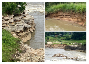
Figure 1: Erosional signs along the Mundeni river basin. Photograph by the author, 2025
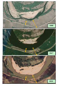
Figure 2: Riverbank erosion changes observed in different years (Source: Google Earth historical imagery, 2009, 2017 and 2025).
