
From Space to Seafloor: Monitoring Seagrass Ecosystems with Remote Sensing Technology
Along the shallow coastal waters of Malaysia from Port Dickson to the islands of Terengganu and Johor, lies an often overlooked yet highly valuable ecosystem: seagrass meadows. These underwater plants may not be as visually striking as coral reefs, but they play a crucial role in sustaining marine life and maintaining coastal health. Seagrass meadows provide nursery habitats for fish and crabs, feeding grounds for sea turtles, and natural stabilisers for coastal sediments. They also contribute to climate change mitigation by storing significant amounts of carbon in their sediments, making them an important component of the world’s blue carbon ecosystems. Despite their importance, seagrass habitats are increasingly under pressure from coastal development, tourism activities, pollution, and declining water quality. Monitoring the condition and distribution of these underwater ecosystems is therefore essential for effective conservation and sustainable coastal management. However, traditional monitoring methods such as diving surveys are often time-consuming and limited to small areas. To overcome these challenges, scientists are increasingly using remote sensing technology to monitor seagrass ecosystems. By using satellite images and drone-based aerial surveys, researchers can observe large coastal areas and track changes in seagrass habitats more efficiently than ever before.
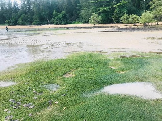
Figure 1: Seagrass meadow observed at Telaga Simpul, Terengganu during low tide conditions.
How Remote Sensing Works
Remote sensing sensors detect electromagnetic energy reflected from the Earth's surface, including shallow seabeds where seagrass grows. Different surfaces reflect light differently. Seagrass leaves, sandy seabeds, and open water each produce distinct spectral signatures that can be detected by satellite or drone sensors. By analysing these spectral differences using Geographic Information Systems (GIS) and digital image processing techniques, researchers can identify areas where seagrass is present and estimate the density and spatial distribution of seagrass meadows. This approach allows scientists to map seagrass habitats efficiently and monitor changes in their coverage over time.
Challenges in Monitoring Underwater Vegetation
Despite its many advantages, detecting seagrass using remote sensing remains challenging because the plants grow beneath the water surface. One of the main limitations is light penetration in water. Sunlight must pass through the water column before reaching the seabed where seagrass grows, and only a portion of this light is reflected back to the satellite or drone sensor. As water depth increases, the amount of light reaching the seabed decreases, making it more difficult for sensors to detect underwater vegetation. For this reason, remote sensing is generally most effective in clear and shallow coastal waters where sufficient light can penetrate to the seabed. Another important challenge is water turbidity, which occurs when sediments, organic particles, or pollutants are suspended in the water. Turbid water reduces water clarity and scatters incoming light, often obscuring seagrass beds from satellite imagery. This situation commonly occurs in coastal areas influenced by river discharge, coastal development, or strong wave activity that resuspends sediments from the seabed. Surface reflections, known as sun glint, can also interfere with remote sensing images. Sun glint occurs when sunlight reflects directly off the water surface into the sensor, creating bright patches that can mask the underlying seabed and make it difficult to identify seagrass habitats. In addition, seagrass may sometimes produce spectral signals similar to algae or seabed materials such as sand and mud, which can complicate image classification and lead to uncertainty in distinguishing between different seabed features. Environmental conditions in tropical regions present additional challenges. Frequent cloud cover, which is common in Malaysia and other equatorial regions, can block satellite sensors from capturing clear images of coastal areas. As a result, researchers may need to wait for suitable weather conditions or combine multiple satellite images over time to obtain cloud-free observations of seagrass habitats. Because of these factors, remote sensing analysis for seagrass monitoring often requires careful data processing and validation with field observations to ensure that the mapped seagrass distribution accurately represents real conditions in the coastal environment.
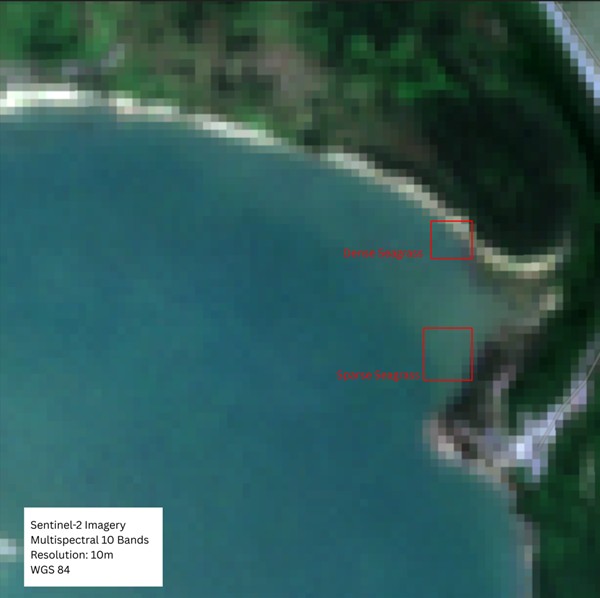
Sentinel-2 multispectral imagery (10 m spatial resolution) showing coastal shallow-water areas with indicative locations of dense and sparse seagrass beds.
Overcoming the Challenges
To improve the accuracy of remote sensing for seagrass monitoring, researchers use several strategies. High-resolution satellite sensors and multispectral or hyperspectral imagery allow scientists to detect subtle differences between seagrass and surrounding seabed features. Drone-based surveys are also increasingly used to collect detailed images of shallow seagrass habitats. These high-resolution images help researchers identify small seagrass patches that may not be visible in satellite imagery. Advanced image processing techniques such as water column correction and sun glint correction are applied to reduce distortions caused by water depth and surface reflections. Selecting images captured during calm sea conditions and periods of clearer water can further improve detection accuracy. Artificial intelligence and machine learning algorithms are also being used to improve the classification of seagrass habitats from satellite imagery. Finally, remote sensing results must be validated through field observations, including diver surveys, underwater photography, and direct sampling of seagrass species. Combining satellite data with field verification ensures that seagrass maps are accurate and reliable.
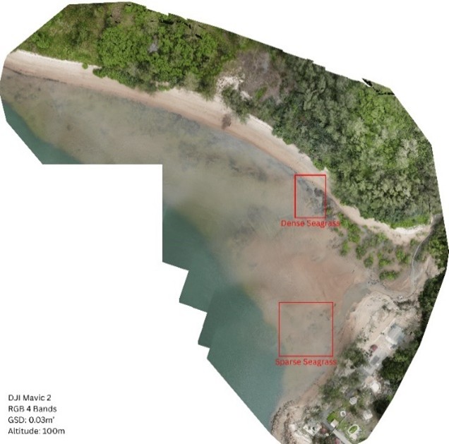
High-resolution drone orthomosaic showing seagrass distribution along a shallow coastal area
Looking Ahead
Looking ahead, rapid technological developments are expected to make remote sensing even more effective for monitoring seagrass ecosystems. New satellites with higher image resolution will allow scientists to detect smaller and more scattered seagrass patches that are currently difficult to observe. The development of hyperspectral sensors, which can capture more detailed information about how light interacts with underwater vegetation, may also help researchers better distinguish seagrass from algae, sand, or other seabed materials. In addition, the growing use of artificial intelligence and machine learning is also expected to make image analysis faster and more accurate. At the same time, improvements in drone technology and underwater monitoring tools will provide more detailed local observations that complement satellite data. Together, these advances are expected to strengthen our ability to monitor and protect seagrass ecosystems more effectively in the future.
“What we cannot easily see beneath the sea must not be forgotten..”
